Skip to primary content
Skip to secondary content

Hiking Angeles Forest

Hiking Angeles Forest

Main menu

  • Home
  • 12 Peak Challenge
    • 12 Peak Challenge Registry of Official Finishers
    • 12 Peak Challenge Thru Hike #1
    • My 12-Peak Challenge Hikes 2017
    • My 12-Peak Challenge Hikes 2018
    • My 12-Peak Challenge Hikes 2019
  • 2019 Hikes
  • About
    • Awards
  • Backpacking
    • Backpacking In Angeles Forest
    • Backpacking Outside Angeles Forest
  • Contact
  • Galleries
    • 360 Degree Panoramas
    • Blue Sky Backgrounds
    • Creatures
    • Details, Patterns, and Textures
    • Header Images
    • Panoramas
    • Snags
    • Sun and Sunsets
    • Trails
    • Trees
    • Trees From Below
    • Views from Peaks
    • Views from Trails
    • Water
  • Hikes
    • 52 Hike Challenge 2018
      • 52 Hike Challenge 2016
      • 52 Hike Challenge 2017
    • Hikes By Distance
    • Hikes From Trailheads
      • Angeles Crest Mile Marker 62.50 (PCT)
      • Angeles Crest MM 54.10 Trailhead
        • AC MM 54.10 to Mt. Hillyer Lollipop
        • AC MM 54.10 to Winston Peak
        • AC mm54.10 scouting hike
        • West Mt. Waterman Trail and Lower West Mt. Waterman Ridge Loop
        • West Mt. Waterman Trail and Ridge to Mt. Waterman
      • Angeles Crest MM 56.00 Trailhead
        • Angeles Crest Mile Marker 56.00 to Cooper Canyon CG, Winston Ridge, Bump 6903, and Winston Peak
      • Bailey Canyon Trailhead
        • Bailey Canyon to Jones Peak
      • Baldy Notch-Ski Lift Trailhead
        • Baldy Notch to Mt. Baldy
      • Burkhart Trailhead
      • Chantry Flats Trailhead
        • Chantry Flat to Hermit Falls, Sturtevant Falls, and Spruce Grove CG
        • Mt. Wilson: Gabrieleno Trail, Upper Falls, Sturtevant, Upper Winter Creek Loop
        • Mt. Zion Loop and Sturtevant Falls via Upper Falls and Lower Winter Creek
        • Mt. Zion Loop via Upper Falls and Upper Winter Creek
      • Charlton Flats (at Angeles Crest Highway)
        • Charlton Flats to Vetter Mountain
        • Charlton Flats to Vetter Mountain Lollipop
      • Chilao Trailhead (North T1)
        • Chilao to Mt. Hillyer
        • Chilao to Mt. Hillyer Lollipop
      • Chilao Trailhead (South T2)
        • Little Pines Loop to Mt. Hillyer
        • Little Pines Loop to Mt. Hillyer Lollipop
        • Little Pines Loop to Vetter Mountain
        • Little Pines Loop to Vetter Mountain via VMT
      • Cloudburst Summit Trailhead
        • Cloudburst Summit to Cooper Canyon Campground to Winston Peak Overnight
        • Cloudburst Summit to Cooper Canyon Falls, Winston Ridge, and Winston Peak
        • Cloudburst Summit to Winston Ridge, Bump 6903, and Winston Peak
      • Cobb Estate Trailhead / Sam Merrill Trail
        • Cobb Estate to Bear Canyon Campground
        • Cobb Estate to Echo Mountain
        • Cobb Estate to Echo Mountain, Cape of Good Hope
        • Cobb Estate to Tom Sloane Saddle
        • Inspiration Point via Castle Canyon Trail from Cobb Estate
        • Mt. Lowe Railway Trails to Mt. Lowe from Cobb Estate
        • Muir Peak Lollipop from the Cobb Estate
        • Muir Peak, Inspiration Peak, and Echo Mountain Lollipop from the Cobb Estate
        • Sam Merrill Trail to Inspiration Point
        • Sam Merrill Trail to Mt. Lowe
        • Sam Merrill Trail, Castle Canyon Trail, and East Mt. Lowe Trails to Mt. Lowe
        • Upper Bear Canyon [p]
      • Colby Canyon Trailhead
        • Colby Canyon to Josephine Peak
        • Colby Canyon to Josephine Peak and Strawberry Meadow
        • Colby Canyon to Josephine Saddle
      • Crystal Lake Campground Trailhead
        • Crystal Lake CG to Mt. Islip Loop
        • Crystal Lake CG to Throop Peak and Mt. Hawkins
      • Dawson Saddle Trailhead
        • Dawson Saddle to Mt. Baden-Powell
        • Dawson Saddle to Mt. Baden-Powell, Mt. Burnham, and Throop Peak
        • Dawson Saddle to Mt. Burnham and Throop Peak
        • Dawson Saddle to Mt. Hawkins
        • Dawson Saddle To Mt. Lewis
        • Dawson Saddle to Mt. Lewis and Throop Peak
        • Dawson Saddle to Throop Peak
        • Dawson Saddle to Throop Peak Lollipop
      • Devil’s Canyon Trailhead
        • Devil’s Canyon to Trailcamp
      • Eagles Roost Picnic Area Trailhead
        • Eagle’s Roost to Mt. Williamson (all bumps)
      • East Fork Trailhead
        • Bridge to Nowhere via Lower San Gabriel Canyon
      • Eaton Canyon Trailhead
        • Eaton Canyon to Eaton Falls
      • Eaton Saddle Trailhead
        • Eaton Saddle to Mt. Lowe
        • Eaton Saddle to Mt. Lowe and Brown Mountain
        • Eaton Saddle to Mt. Lowe, Echo Mountain, and Inspiration Point
        • Eaton Saddle to Mt. Lowe, Inspiration Point, Muir Peak, and Mt. Markham
        • Eaton Saddle to Mt. Markham
        • Eaton Saddle to San Gabriel Peak
        • Eaton Saddle to Valley Forge Campground
      • Gabrieleno Trail (JPL) Trailhead
        • Gabrieleno Trail to Oakwilde and Debris Dam
      • Icehouse Canyon Trailhead
        • Icehouse Canyon and Chapman Trail Loop to Icehouse Saddle
        • Icehouse Canyon to Icehouse Saddle to Cedar Glen
      • Islip Saddle Trailhead
        • Islip Saddle to Middle Mt. Hawkins and Mt. Islip
        • Islip Saddle to Mt. Islip
        • Islip Saddle to Mt. Islip Loop
        • Islip Saddle to Throop Peak and Mt. Hawkins
        • Mt. Williamson Shuttle Hike
        • South Fork Trail
      • Manker Flats Trailhead
        • Baldy Bowl Trail (aka Ski Hut Trail) To Mt. Baldy
        • Baldy Bowl Trail and Devil’s Backbone Loop To Mt. Baldy
      • Mill Creek Picnic Area Trailhead
        • Mill Creek to Mt. Pacifico
        • Mill Creek to Mt. Pacifico Loop
      • Millard Canyon Trailhead
        • Lower Sunset Ridge to Millard Falls
        • Millard Canyon to Bear Canyon Campground
        • Millard Canyon to Dawn Mine
        • Millard Canyon to Dawn Mine to Echo Mountain Loop
        • Millard Falls, Millard Canyon, and Dawn Mine to Echo Mountain Loop
        • Sunset Ridge Trail to Echo Mountain
        • Upper Sunset Ridge Trail from the gate to Muir Peak
        • Upper Sunset Ridge Trail to Echo Mountain
        • Upper Sunset Ridge Trail to Mt. Lowe
      • Mt. Waterman Trailhead
        • Mt. Waterman Loop
        • Mt. Waterman Trail to Summit
      • Mt. Wilson Trailhead, Sierra Madre
      • Red Box Trailhead
        • Red Box to Strawberry Meadow
        • Red Box to Strawberry Peak
        • Red Box to Upper Switzer Picnic Area
        • Red Box to Valley Forge, Mt. Lowe, and San Gabriel Peak
        • Red Box to West Fork Campground Lollipop
      • Rosenita Saddle Trailhead
        • Rosenita Saddle to Mt. Hillyer Lollipop
      • San Gabriel Peak Trailhead
        • San Gabriel Peak Trail
        • San Gabriel Peak Trailhead to Mt. Deception, Deception Plateau, Mt. Disappointment and San Gabriel Peak
        • San Gabriel Peak Trailhead to San Gabriel Peak and Mt. Markham
        • San Gabriel Peak Trailhead to San Gabriel Peak, Mt. Lowe, and Mt. Muir
        • San Gabriel Peak Trailhead to San Gabriel Peak and Mt. Lowe
      • Silver Moccasin Trailhead (Shortcut Saddle)
        • Shortcut Saddle to Devore Trail Camp
        • Shortcut Saddle to Newcomb Pass Lollipop
        • Shortcut Saddle to Vetter Mountain Lollipop
        • Silver Moccasin Trail from Shortcut Saddle to Vetter Mountain
        • Silver Moccasin Trail: Shortcut Saddle to Charlton Flats
      • South Fork Trailhead
        • Manzanita Trail to Vincent Gap
        • South Fork to Devil’s Chair
      • Switzer Picnic Area
        • Switzer Picnic Area to Bear Canyon Campground and Switzer Falls.
        • Switzer Picnic Area to Oakwilde
        • Switzer Picnic Area to Switzer Falls
        • Switzer Picnic Area to Switzer Falls and the Arroyo Seco to Bear Canyon.
      • Three Points Trailhead
        • Three Points to Mt. Hillyer
        • Three Points to Mt. Hillyer Lollipop
        • Three Points to Mt. Waterman Loop
        • Three Points to Sulphur Springs Campground
        • Three Points to Winston Peak
      • Trail Canyon Trailhead
        • Trail Canyon to Falls
        • Trail Canyon to Falls and Tom Lucas CG Area
      • Vincent Gap Trailhead
        • Vincent Gap to Mt. Baden Powell
    • Hiking Journals 2013-2017
      • 2013 Hikes
      • 2014 Hikes
      • 2015 Hikes
      • 2016 Hikes
      • 2017 Hikes
      • 2018 Hikes
    • Peak Routes In Angeles Forest
      • Barley Flats
      • Bighorn Peak
      • Brown Mountain
      • Bump 6903
      • Copter Ridge
      • Cucamonga Peak
      • Fox Peak
      • Inspiration Peak (unoffical name)
      • Jones Peak
      • Josephine Peak
      • Kratka Ridge
      • Mt. Baden-Powell
      • Mt. Baldy (Mt. San Antonio)
      • Mt. Burnham
      • Mt. Deception
      • Mt. Disappointment
      • Mt. Harwood
      • Mt. Hawkins
      • Mt. Hawkins (Middle)
      • Mt. Hawkins (South)
      • Mt. Hillyer
      • Mt. Islip
      • Mt. Lawlor
      • Mt. Lewis
      • Mt. Lowe
      • Mt. Lukens
      • Mt. Markham
      • Mt. Pacifico
      • Mt. Waterman
      • Mt. Williamson
        • Mt. Williamson (Middle)
        • Mt. Williamson (West)
      • Mt. Wilson
      • Mt. Zion
      • Muir Peak
      • Ontario Peak
      • Pallett Mountain
      • Pallett Mountain #2
      • Peak UTM 113016
      • Roundtop
      • San Gabriel Peak
      • Strawberry Peak
      • Telegraph Peak
      • Throop Peak
      • Thunder Mountain
      • Timber Mountain
      • Twin Peaks (East)
      • Vetter Mountain
      • West Baldy
      • Will Thrall Peak
      • Winston Peak
      • Winston Ridge
    • Requiring a Shuttle
      • San Gabriel Peak Trailhead to Eaton Saddle Trailhead
      • Silver Moccasin Trail from Angeles Crest Highway to Charlton Flats at Angeles Crest Highway
      • Silver Moccasin Trail from Shortcut Saddle to Vetter Mountain to Charlton Flats
      • Sunset Ridge Trail from Millard Canyon to Echo Mountain to Cobb Estate
      • Upper Sunset Ridge Trail from Gate to Echo Mountain to Cobb Estate
    • Trails Traversing Multiple Trailheads
      • Gabrieleno Trail Hikes
        • Red Box to Valley Forge
      • Pacific Crest Trail Hikes
      • Silver Moccasin Trail
        • Silver Moccasin Trail from Angeles Crest Highway to Little Pines Loop
        • Silver Moccasin Trail from Shortcut Saddle to West Fork Trail Camp
        • Silver Moccasin Trail: Chilao to Bandito Campground
        • Silver Moccasin Trail: Chilao to Horse Flats Campground
        • Silver Moccasin Trail: Three Points to Bandito Campground
        • Silver Moccasin Trail: Three Points to Horse Flats
    • Whitney Training Hikes
      • Icehouse Canyon to Mt. Baldy
  • Hiking Links
  • My Map
  • Other Locations
    • Ancient Bristlecone Pine Forest Photos
      • Grandview Campground [p]
      • Methuselah Walk [p]
      • Vista Point Between Grandview Campground and Schulman Grove [p]
    • Anza-Borrego Desert State Park
      • CH: 26 Trip 1: Lower Willows
        • Lower Willows Trail [p]
        • Palm Grove within Santa Catarina Spring area [p]
        • Road into Coyote Canyon between 2nd and 3rd stream crossings [p]
        • Santa Catarina Spring Monument Area [p]
        • Valley Road back to 3rd stream crossing [p]
      • CH: 29 Trip 5: Rock Tanks Loop
        • ABDSP Peak 2152
        • American Indian Trail connecting Palo Verde Wash and Smoke Tree Canyon [p]
        • Palo Verde Wash [p]
        • Smoke Tree Canyon [p]
      • CH: 36 Trip 5: Bow Willow Canyon
        • Bow Willow Canyon [p]
      • CH: 37 Trip 3: Arroyo Tapiado & Arroyo Seco del Diablo Loop
        • Arroyo Diablo Road [p]
        • Arroyo Seco del Diablo [p]
        • Arroyo Tapiado [p]
      • Culp Valley Campground [p]
      • Culp Valley Trail [p]
    • Carrizo Plain National Monument
    • Cleveland National Forest
      • Agua Tibia Loop Hike
        • Dripping Springs Trail Photos
        • Palomar-Magee Trail Photos
        • Wild Horse Trail Photos
      • Laguna Mountains
        • Monument Peak, Laguna Meadow Loop
    • Grand Canyon
      • Grand Canyon Photos
        • Bright Angel Trail
        • North Kaibab Trail from Bright Angel CG to Cottonwood CG
        • North Kaibab Trail: Cottonwood Campground to North Rim
        • Ribbon Falls
        • South Kaibab Trail
      • Grand Canyon Posts
    • Humboldt Redwoods State Park
      • Founders Grove and Mahan Loop [p]
    • Inyo National Forest
      • White Mountain and Trail
    • Kings Canyon National Park
      • Kings Canyon National Park Photos
        • Buena Vista Peak and Trail
        • Grant Grove
        • Lookout Peak and Trail
    • Little Lakes Valley
      • Little Lakes Valley Photos
        • Little Lakes Valley: Mosquito Flat to Morgan Pass
        • Rock Creek Lake Campground
    • Los Padres National Forest
      • Cold Springs Trail to Montecito Peak
      • Jesusita Trail to Inspiration Point
      • Red Rock to Gibralter Dam
      • Upper Oso Canyon To Nineteen Oaks
    • Mt. San Jacinto Wilderness Areas
      • Mt. San Jacinto Wilderness Photos
        • Little Round Valley to JCT Mt. San Jacinto
        • Little Round Valley to JCT PCT
        • Marion Mountain Trail
        • Mt. San Jacinto
        • PCT: JCT Marion Mountain Trail to Fuller Ridge
    • Mt. Whitney
      • Mt. Whitney Photos
        • Whitney Portal to Mt. Whitney
          • 1. Trailhead at Whitney Portal to JCT Lone Pine Lake
          • 2. Lone Pine Lake
          • 3. JCT Lone Pine Lake to Mirror Lake
          • 3A: Bighorn Park
          • 4. Mirror Lake
          • 5. Mirror Lake to Trail Camp
          • 5A: Consultation Lake
          • 6. Trail Camp
          • 7. Trail Camp to John Muir Trail Junction
          • 8. John Muir Trail: JCT Whitney Trail to Summit Approach
          • 9. JMT: Summit Approach to Mt. Whitney
      • Mt. Whitney Posts
    • Peaks Outside Angeles Forest
      • Pinyon Peak
      • Sandstone Peak
      • Wright Mountain
    • Pinnacles National Park
    • Point Reyes State Reserve
    • Redwood National Park
      • Emerald Ridge Trail [p]
      • Redwood Creek [p]
      • Tall Trees Grove and Trail [p]
    • San Gorgonio Wilderness
      • San Gorgonio Wilderness Photos
        • Dry Lake / Dry Lake Trail
        • Limber Pine Bench
        • Mt. San Gorgonio
        • San Bernardino Peak
        • Sky High Trail
        • South Fork Trail SGW [p]
        • Vivian Creek Trail
      • San Gorgonio Wilderness Posts
    • Santa Monica Mountains
      • Backbone Trail [p]
      • Mishe Mokwa Trail [p]
    • Sequoia
      • Sequoia Photos
        • Alta Trail
          • Alta Peak
          • JCT Alta Meadow to Alta Peak
          • JCT Congress Trail to Panther Gap
          • JCT High Sierra Trail to Mehrten Meadow
          • Mehrten Meadow to JCT Alta Meadow
          • Panther Gap to JCT High Sierra Trail
          • Parts of Alta Trail and Trail of the Sequoias
        • Big Trees Trail/Beetle Rock
        • Congress and Sherman Tree Trails
        • Crescent Trail
        • Hanging Rock
        • Lakes Trail
        • Little Baldy
        • Little Baldy Trail
        • Marble Fork Trail
        • Moro Rock Crescent Meadow Access Road
        • Muir Grove Trail
        • Panoramas
        • Panther Gap Trail
      • Sequoia Posts
  • Peak Bagging Routes
  • Points of Interest
    • Campgrounds
      • Bandito Campground (Car Camping)
      • Cedar Glen Trail Camp
      • Cooper Canyon Campground
      • Horse Flats Campground (Car Camping)
      • Idlehour Trail Camp
      • Inconspicuous Trail Camp Near Mt. Baldy
      • Little Jimmy Campground
      • South Fork Campground (Car Camping)
      • Valley Forge Campground
    • Man Made
      • Bridge to Nowhere
      • Echo Mountain White City Ruins
      • Inspiration Point
      • Mueller Tunnel
    • Natural
      • Josephine Saddle
      • Strawberry Meadow/Potrero
  • References
    • Authors
      • Bruman, J. R.
      • Christiansen, Doug
      • Klauber, Lawrence M.
      • Martin, Don and Martin, Kay
      • Preston, Richard
      • Robinson, John W.
      • Schad, Jerry
      • Smith, Dave
      • Stone, Robert
      • White, Mike
    • Blogs
      • 1000 Miles
      • Back Yard Biology
      • Looking For Treasure
      • My Life As Abraham Lincoln
    • Books
      • 106 Tops In The Angeles Forest
      • Afoot & Afield: Los Angeles County
      • Afoot & Afield: San Diego County
      • Backcountry Bear Basics
      • Day Hikes Around Big Sur: 80 Great Hikes
      • Day Hikes Around Sonoma County: 95 Great Hikes
      • Day Hikes On The California Central Coast: 120 Coastal Hikes From Santa Cruz To Santa Barbara
      • Hiking Marin: 141 Hikes in Marin County
      • Rattlesnakes: Their Habbits, Life Histories, & Influence
      • The Wild Trees
      • Top Trails: Northern California’s Redwood Coast
      • Trails of the Angeles: 100 Hikes in the San Gabriels
    • Forest Life
      • Birds
        • American Robin
        • Mourning Dove
        • White-breasted Nuthatch
      • Bugs and Insects
        • Cabbage White Butterfly
      • Edible Plants
        • Miner’s Lettuce
      • Poisonous Plants
        • Poodle Dog Bush
      • Reptiles and Amphibians
        • California Tree Frog
        • Gopher Snake
        • Great Basin Collared Lizard
      • Trees
        • Limber Pine
    • Maps
      • Angeles Front Country Trail Map
      • Angeles High Country Trail Map
      • Redwood National and State Parks (South)
  • Trail Photos
    • Angeles Crest Mile Marker 54.10 Photos
      • Lower West Mt. Waterman Ridge [p]
      • Upper West Mt. Waterman Ridge [p]
      • West Mt. Waterman Trail [p]
    • Burkhart Trail Photos
      • Burkhart Trail: Buckhorn Campground to JCT Cooper Canyon Trail [p]
      • Burkhart Trail: JCT Cooper Canyon Trail to JCT Rattlesnake Trail [p]
      • Burkhart Trail: JCT Rattlesnake Trail to Burkhart Saddle [p]
    • Charlton Flats Trail Photos
      • Angeles Crest Parking to JCT Silver Moccasin Trail [p]
      • JCT Silver Moccasin Trail to Vetter Mountain [p]
    • Cloudburst Summit Trail Photos
      • South Winston Peak Use Trail [p]
    • Cobb Estate Trail Photos
      • Brown Mountain Use Trail [p]
      • Castle Canyon [p]
      • East Mt. Lowe [p]
      • Inspiration Peak Hiker’s Trail [p]
      • Lower Sam Merrill [p]
      • Middle Sam Merrill Trail [p]
      • Muir Peak Trail [p]
      • OM&M Railway Trail 1 [p]
      • Tom Sloan Saddle Trail [p]
      • Upper Sam Merrill Trail [p]
    • Colby Canyon Trail Photos
      • Josephine Saddle Trail [p]
      • South Colby Canyon Trail [p]
      • Upper Josephine Peak Road [p]
    • Dawson Saddle Photos
      • Dawson Saddle Trail [p]
      • Mt Lewis Use Trail [p]
      • Throop Peak Trail [p]
    • Devil’s Canyon Trail Photos
      • Middle Devil’s Canyon [p]
    • East Fork Photos
      • Lower San Gabriel Canyon Trail [p]
    • Eaton Saddle Photos
      • Eaton Saddle to Markham Saddle [p]
      • Lower North Mt. Lowe Trail [p]
      • Mt. Markham Trail [p]
      • South San Gabriel Peak Trail [p]
      • Upper East Mt. Lowe [p]
      • Upper North Mt. Lowe Trail [p]
      • Valley Forge Trail [p]
    • Exploring
      • Exploring Echo Mountain to Rubio Canyon to ? [p]
    • Gabrieleno Trail Photos
      • GT: Red Box to Valley Forge [p]
    • Icehouse Canyon Trail Photos
      • Bighorn Peak Trail [p]
      • Chapman Trail [p]
        • Lower Chapman Trail [p]
        • Upper Chapman Trail [p]
      • Cucamonga Peak Trail [p]
      • Icehouse Canyon Trail [p]
        • Lower Icehouse Canyon [p]
        • Middle Icehouse Canyon [p]
        • Upper Icehouse Canyon [p]
      • Ontario Peak Trail [p]
        • Lower Ontario Peak Trail [p]
        • Middle Ontario Peak Trail [p]
        • Upper Ontario Peak Trail [p]
    • Islip Saddle Trail Photos
      • Islip Ridge Trail: Windy Gap to Mt. Islip [p]
      • Mt. Islip Trail: Little Jimmy to Mt. Islip [p]
      • South Fork Trail [p]
    • Manker Flats Trail Photos
      • Baldy Bowl Trail [p]
      • Baldy Bowl Upper “Little Bowl” Variant [p]
      • Devil’s Backbone Trail [p]
      • Mt. Harwood Summit Trail [p]
      • Register Ridge [p]
      • West Baldy Trail [p]
    • Millard Canyon Trail Photos
      • Lower Mt. Lowe Railway Trail [p]
      • Lower Sunset Ridge Trail [p]
      • Mt. Lowe Campground Trail [p]
      • Upper Mt. Lowe Railway Trail [p]
      • Upper Sunset Ridge [p]
    • Mt. Waterman Trail Photos
      • Mt. Waterman Summit Trail [p]
      • Mt. Waterman Trail 1 [p]
    • North Backbone Trail 1 [p]
    • North Backbone Trail 2 [p]
    • Pacific Crest Trail Photos
      • PCT: Angeles Crest Mile Marker 54.10 to Three Points [p]
      • PCT: Cloudburst Summit to Gate on Angeles Crest Highway [p]
      • PCT: Gate on Angeles Crest Highway to Mile Marker 54.10 Crossing [p]
      • PCT: Islip Saddle to JCT Pleasant View Ridge [p]
      • PCT: JCT Mt. Baden-Powell to JCT Dawson Saddle [p]
      • PCT: JCT Pleasant View Ridge to Angeles Crest HWY [p]
      • PCT: Little Jimmy to Islip Saddle [p]
      • PCT: Vincent Gap to JCT Mt. Baden-Powell [p]
      • PCT: Windy Gap to Little Jimmy [p]
    • Pleasant View Ridge Trail Photos
      • PVR: Middle Mt. Williamson to West Mt. Williamson [p]
      • PVR: Pacific Crest Trail to Mt. Williamson [p]
        • PVR: Mt. Williamson to Middle Mt. Williamson [p]
      • PVR: Pallett Mountain to Burkhart Saddle
      • PVR: West Mt. Williamson to Pallett Mountain [p]
    • Red Box Trail Photos
      • Barley Road [p]
      • North Strawberry Saddle Trail [p]
      • South Strawberry Saddle Trail [p]
      • Strawberry Peak Trail [p]
    • Rosenita Saddle Trail Photos
      • North Mt. Hillyer Trail [p]
    • San Gabriel Peak Trail Photos
      • Lower San Gabriel Peak [p]
      • Upper San Gabriel Peak [p]
    • Silver Moccasin Trail Photos
      • SMT: Bandito Campground to Three Points [p]
      • SMT: Fire Road JCT to Little Pines Loop [p]
      • SMT: Horse Flats to Bandito Campground [p]
      • SMT: Little Pines Loop to North Chilao [p]
      • SMT: North Charlton Flats to JCT Leaving Fire Road [p]
      • SMT: North Chilao to Horse Flats [p]
      • SMT: Shortcut Saddle to Charlton Flats [p]
      • SMT: West Fork Trail Camp to Angeles Crest Highway [p]
    • Three Points Photos
      • Mt. Hillyer North Hiker’s Trail [p]
      • Mt. Hillyer Trail 1 [p]
      • South Mt. Waterman Trail: 3 points to JCT Twin Peaks Trail [p]
      • South Mt. Waterman Trail: JCT Twin Peaks to JCT Summit Trail [p]
  • Trail Segments
    • Angeles Crest Mile Marker 54.10 Segments
      • Lower West Mt. Waterman Ridge [s]
      • Upper West Mt. Waterman Ridge [s]
      • West Mt. Waterman Trail [s]
    • Burkhart Trail Segments
      • Buckhorn CG to JCT Cooper Canyon Trail [s]
      • JCT Cooper Canyon Trail to JCT Rattlesnake Trail [s]
      • JCT Rattlesnake Trail to Burkhart Saddle [s]
    • Chantry Flat Segments
      • Sturtevant Trail: JCT Gabrieleno Trail to Upper JCT Mt. Zion Trail. [s]
      • Sturtevant Trail: Upper JCT Mt. Zion Trail to Mt. Wilson [s]
      • Upper Falls Trail
      • Upper Winter Creek Trail Junction to Manzanita Ridge [s]
      • Upper Winter Creek Trailhead to Upper Winter Creek Trail Junction [s]
    • Charlton Flats Trail Segments
      • Angeles Crest Parking to JCT Silver Moccasin Trail [s]
      • JCT Silver Moccasin Trail to Vetter Mountain [s]
    • Cloudburst Summit Trail Segments
      • South Winston Peak Hiker’s Trail [s]
    • Cobb Estate Trail Segments
      • Brown Mountain Hiker’s Trail [s]
      • Castle Canyon Trail [s]
      • East Mt. Lowe [s]
      • Inspiration Peak Hiker’s Trail [s]
      • Inspiration Point to Lowe Saddle [s]
      • Junction at Echo Mountain [s]
      • Lowe Saddle to Inspiration Point [s]
      • Lowe Saddle [s]
      • Lower Sam Merrill Trail [s]
      • Middle Sam Merrill Trail [s]
      • Mt. Lowe Road [s]
      • Muir Peak Trail [s]
      • OM&M Railway Trail 1 [s]
      • Tom Sloane Saddle Trail [s]
      • Upper Bear Canyon [s]
      • Upper Sam Merrill Trail [s]
    • Colby Canyon Trail Segments
      • Josephine Saddle Trail [s]
      • South Colby Canyon Trail [s]
      • Upper Josephine Peak Road [s]
    • Dawson Saddle Segments
      • Dawson Saddle to PCT [s]
      • Mt. Lewis use trail [s]
      • Throop Peak Trail (s)
    • East Fork Trail Segments
      • Heaton Road [s]
      • Lower San Gabriel Canyon [s]
    • Eaton Saddle Segments
      • Eaton Saddle to Markham Saddle [s]
      • Lower North Mt. Lowe Trail [s]
      • Mt. Markham Hiker’s Trail [s]
      • South San Gabriel Peak Trail [s]
      • Trail to Mt. Lowe Summit [s]
      • Upper East Mt. Lowe [s]
      • Upper North Mt. Lowe Trail [s]
      • Valley Forge Trail [s]
      • West Mt. Lowe Ridge Hiker’s Trail [s]
    • Gabrieleno Trail Segments
      • GT: Chantry Flat to JCT Lower Winter Creek [s]
      • GT: Falling Sign JCT to Sturtevant Trail [s]
      • GT: JCT Lower Winter Creek to Fern Lodge Junction [s]
      • GT: Red Box to Valley Forge [s]
    • Icehouse Canyon Trail Segments
      • Lower Chapman Trail [s]
      • Lower Icehouse Canyon [s]
      • Middle Icehouse Canyon [s]
      • Upper Chapman Trail [s]
      • Upper Icehouse Canyon [s]
    • Islip Saddle Trail Segments
      • Islip Ridge Trail: Windy Gap to Mt. Islip [s]
      • Mt. Islip Trail: Little Jimmy to Mt. Islip [s]
      • South Fork Trail [s]
    • Manker Flats Segments
      • Baldy Bowl Trail (aka Ski Hut Trail) [s]
      • Baldy Bowl Upper “Little Bowl” Variant [s]
      • Devil’s Backbone Trail [s]
      • Mt. Harwood Summit Trail [s]
      • Register Ridge [s]
      • West Baldy Trail [s]
    • Millard Canyon Trail Segments
      • Lower Mt. Lowe Railway Trail [s]
      • Lower Sunset Ridge Trail [s]
      • Mt. Lowe Campground Trail [s]
      • Upper Mt. Lowe Railway Trail [s]
      • Upper Sunset Ridge Trail [s]
    • Mt. Waterman Segements
      • Mt. Waterman Summit Trail 1 [s]
      • Mt. Waterman Trail 1 [s]
    • Mt. Wilson Trail Segments
      • 4. Mt. Wilson Trail from Manzanita Ridge to Mt. Wilson Toll Road [s]
      • 5. Mt. Wilson Trail from Mt. Wilson Toll Road to Mt. Wilson [s]
      • Mt. Wilson Toll Road from JCT Mt Wilson Trail to JCT Upper Mt. Wilson Trail. [s]
    • Pacific Crest Trail Segments
      • PCT: Cloudburst Summit to Gate on Angeles Crest Highway [s]
      • PCT: Gate on Angeles Crest Highway to Mile Marker 54.10 [s]
      • PCT: Islip Saddle to JCT Pleasant View Ridge [s]
      • PCT: JCT Mt. Baden-Powell to JCT Dawson Saddle [s]
      • PCT: JCT Pleasant View Ridge to Angeles Crest Highway Mile Marker 62.50 [s]
      • PCT: Little Jimmy to Islip Saddle [s]
      • PCT: Mile Marker 54.10 to Three Points [s]
      • PCT: Vincent Gap to JCT Mt. Baden-Powell [s]
      • PCT: Windy Gap to Little Jimmy [s]
    • Pleasant View Ridge Trail Segments
      • PVR: Burkhart Saddle to Pallett Mountain [s]
      • PVR: JCT Pacific Crest Trail to Mt. Williamson [s]
      • PVR: Middle Mt. Williamson to West Mt. Williamson[s]
      • PVR: Mt. Williamson to Middle Mt. Williamson [s]
      • PVR: West Mt. Williamson to Pallett Mountain [s]
    • Red Box Segments
      • Barley Road [s]
      • North Strawberry Saddle Trail [s]
      • South Strawberry Saddle Trail [s]
      • Strawberry Peak Trail [s]
    • Rosenita Saddle Trail Segments
      • North Mt. Hillyer Trail [s]
    • San Gabriel Peak Segments
      • Lower San Gabriel Peak Trail [s]
      • SGP JCT at road to saddle [s]
      • SGP saddle to JCT Upper SGP trail [s]
      • Upper San Gabriel Peak Trail [s]
    • Silver Moccasin Trail Segments
      • SMT: Angeles Crest Highway to Charlton Flats [s]
      • SMT: Bandito Campground to Three Points [s]
      • SMT: Fire Road JCT to Little Pines Loop [s]
      • SMT: Horse Flats to Bandito Campground [s]
      • SMT: Little Pines Loop to North Chilao [s]
      • SMT: North Charlton Flats to JCT Leaving Fire Road [s]
      • SMT: North Chilao to Horse Flats [s]
      • SMT: Through Charlton Flats [s]
      • SMT: West Fork Trail Camp to Angeles Crest Highway [s]
    • Three Points Segments
      • Horse Flats Trail [s]
      • Lower South Mt. Waterman Trail [s]
      • Mt. Hillyer North Hiker’s Trail [s]
      • Mt. Hillyer Trail [s]
      • Upper South Mt. Waterman Trail [s]

Blog Archives

San Gabriel Peak

Gallery

Posted on March 10, 2012 by Kyle Kuns

This gallery contains 12 photos.

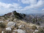
This hike is one of my favorites largely because it reaches the highest peak in the Angeles Forest front country area south of Angeles Crest Highway.  The views are spectacular in all directions and the peak itself is only the … Continue reading →

Posted in Hike | Tagged Angeles Forest, Car Shuttle Hike, Eaton Saddle, Hiking, Mueller Tunnel, San Gabriel Peak, San Gabriel Peak Trail | 7 Replies

Hike: Inspiration Peak Trail

Gallery

Posted on March 3, 2012 by Kyle Kuns

This gallery contains 9 photos.

Since so many hikers already know how to hike to Inspiration Point, I decided to post this trail segment in advance of putting together a complete hike detailing how to get to it–which is forthcoming.  This short one mile trail … Continue reading →

Posted in Hike | Tagged Angeles Forest, Hiking, Inspiration Peak, Inspiration Point, Sam Merrill Trail | 2 Replies

Hike: Eaton Saddle to Mt. Markham

Gallery

Posted on February 28, 2012 by Kyle Kuns

This gallery contains 15 photos.

The difference between this hike and the last one is that it goes to Mt. Markham instead of Mt. Lowe.  I’ve hiked past Mt. Markham a number of times and never took the trail to the summit because there was … Continue reading →

Posted in Hike | Tagged Angeles Forest, Eaton Saddle, Hiking, Mt. Markham, Mueller Tunnel | Leave a reply

Link To My Google Map

Locations have links to more information.

Instagram

From 2-9-2022. Given the warm temperatures last week, I decided to do some easy boulder hopping of the #arroyoseco through part of #royalgorge in #angelesnationalforest #sangabrielmountains for a large portion of my hike. Being in the water combined with shade often created by the walls of the gorge kept me cool. Most of the way it was easy to stay under a foot deep in the water. I reached a few small pools of around 3 feet of depth to wade through. I didn't have time to make it to the falls, so I can't report on conditions that far upstream. Some minor stretches getting through/around branches while in water are required.
From 1-28-2022. I hiked along the #idlehourtrail (from Mt. Wilson Road) for the first time in a while. It was nice to see a new bear box and some new picnic tables at #idlehourtrailcamp. Plenty of water in the stream at the camp as well in #angelesnationalforest #sangabrielmountains
From 1-25-2022. A nice cool day made for a good time to take in a mostly exposed hike along the #oakspringstrail in #angelesnationalforest #sangabrielmountains
From 1-14-2022. Great to hike through #millardcanyon with a nice amount of water flowing and creating little falls and pools along the way to Dawn Mine in #angelesnationalforest #sangabrielmountains
From 1-7-2022. The trail between Switzer Falls and the mouth of Bear Canyon along the #arroyoseco is one of my favorite places to be in #angelesnationalforest This is especially true at times like these when enough water runs through the gorge to form mini-falls and pools along with the sounds that go along with that. #sangabrielmountains

Enter your email address to follow this blog and receive notifications of new posts by email.

RSS Feed RSS - Posts

Recent Posts

  • New Page Additions January through March 2018
  • New Page Additions October Through December 2017.
  • New Page Additions July through September 2017.
  • New Page Additions April through June 2017.
  • New Page Additions January through March 2017
  • A New Approach and New Page Additions
  • 12 Peak Challenge
  • New Page Additions Since July 2016
  • Sand Fire Map (Modis Thermal Satellite + Topo)
  • New Page Additions Since April 2016

Twitter

  • My view last Friday looking toward the 2nd bump of #MtWilliamson as part of my #HAF12peaks challenge in… twitter.com/i/web/status/8… 5 years ago
  • Last Sunday's view from #Mthillyer in #AngelesNationalForest #HAF12peaks https://t.co/SJHGQljsSJ 5 years ago
  • Last Monday's view from #TrailCanyonFalls in #AngelesNationalForest https://t.co/uePab3Wq7m 5 years ago
  • #coopercanyonfalls two days ago. I summited #WinstonRidge and #WinstonPeak on the way back. #HAF12peaks… twitter.com/i/web/status/8… 5 years ago
  • Yesterday's view from the #SanGabrielPeakTrail on my way to #MuirPeak, #MtLowe, and #SanGabrielPeak in… twitter.com/i/web/status/8… 5 years ago
Follow @HikingAF

RSS Feed RSS - Posts

Enter your email address to follow this blog and receive notifications of new posts by email.

Blog at WordPress.com.
  • Follow Following
    • Hiking Angeles Forest
    • Join 608 other followers
    • Already have a WordPress.com account? Log in now.
    • Hiking Angeles Forest
    • Customize
    • Follow Following
    • Sign up
    • Log in
    • Report this content
    • View site in Reader
    • Manage subscriptions
    • Collapse this bar
 

Loading Comments...