
Elevation: 10834′
Hikes:
- From Mountain Station (via the Palm Springs Aerial Tramway) to Mt. San Jacinto and back: 11 miles, 2500′ of gain and loss. First Hike: 7-2-2016
- → Backpacking Trip: Day one: Marion Mountain Trail up to Little Round Valley, set up camp; hike to Mt. San Jacinto and back. Day two: Little Round Valley down to Marion Mountain trailhead: 11.8 miles, 4534′ gain and loss. First Hike: 6-23-2013.
- → Backpacking Trip. Day one: Humber Park Trailhead: Devil’s Slide Trail up to Pacific Crest Trail up to Wellman Divide Trail up to Wellman Divide; down to Round Valley. Day two: Round Valley up to Mt. San Jacinto; down to Little Round Valley, down to Pacific Crest Trail down to Devil’s Slide Trail down to Humber Park. 22.2 miles, 6224′ gain. First Hike: 7-25-2012.
Back to Mt. San Jacinto Photos
Mt. San Jacinto, Mt. San Jacinto Summit Trail and Peak Scramble Photos (Click image to view larger size)
-

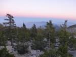
- Mt. San Jacinto
-

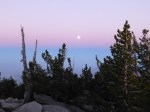
- Mt. San Jacinto
-

- Mt. San Jacinto
-
- Mt. San Jacinto
-
- Mt. San Jacinto
-

- Mt. San Jacinto
-
- Mt. San Jacinto Summit Trail
-
- Mt. San Jacinto Summit Trail
-

- Mt. San Jacinto Peak Scramble
-

- Mt. San Jacinto Peak Scramble
-
- Mt. San Jacinto Peak Scramble
-
- Mt San Jacinto Peak Scramble
