
Hiking Journal of my hikes completed in 2017.
Total Miles Hiked in 2017:
- 395.2 miles with 96,565′ of gain
Miles Hiked in Angeles Forest in 2017:
- 357 miles with 88,204′ of gain
When clicked, all images below open a new tab at a larger size.
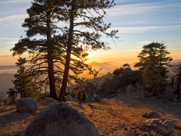
Hike #52 on December 30. In Angeles National Forest, from South Fork, I hiked to High Desert Trail to Devil’s Chair.

High Desert Trail between South Fork and Devil’s Chair (12-30-2017).
Stats: 6 miles, 1,350′ of gain and loss. Points of Interest: Devil’s Chair, South Fork Campground. Trails: The High Desert Trail and the Devil’s Chair Trail. Route description includes track map and step by step route instructions.
Hike #51 on December 3. In Angeles National Forest, from Three Points, I did a loop hike to Mt. Waterman.
View looking down West Mt. Waterman Ridge (12-3-2017).
Stats: 11 miles, 2,520′ of gain and loss. Points of Interest: Mt. Waterman and numerous rock outcrops along the west ridge of Mt. Waterman. Trails: South Mt. Waterman Trail, Mt. Waterman Summit Trail, West Mt. Waterman Ridge (part mild x-county, part faint hiker’s trail). Route description includes track map, step by step route instructions with segment pages, and links to photo galleries.
Hike #50 on November 30. In Angeles National Forest, from Shortcut Saddle, I hiked to Devore Trail Camp.

View of the San Gabriel River along the Gabrieleno Trail between West Fork Trail Camp and Devore Trail Camp (11-30-2017).
Stats: 9 miles, 1,890′ of gain and loss. Points of Interest: West Fork Trail Camp, Devore Trail Camp, Creek through Shortcut Canyon, San Gabriel River. Trails: Silver Moccasin Trail and Gabrieleno Trail. Route description includes track map, step by step route instructions with segment pages, links to photo galleries, and links to blog pages.
Hike #49 on November 26. In Angeles National Forest, from Islip Saddle, I hiked to Mt. Islip.

View from the Pacific Crest Trail between Little Jimmy and Islip Saddle (11-26-2017).
Stats: 6.7 miles, 1,580′ of gain and loss. Points of Interest: Little Jimmy Campground, Little Jimmy Spring, Mt. Islip. Trails: Pacific Crest Trail, Islip Ridge Trail, Islip Summit Trail, Mt. Islip Trail. Route description includes track map, step by step route instructions with segment pages, link to Points of Interest page, and links to photo galleries.
Hike #48 on November 22. In Angeles National Forest, from Cloudburst Summit, I hiked to Winston Ridge, Bump 6903, and Winston Peak with Sarah.

View from the Winston Ridge Trail (11-22-2017).
Stats: 4.7 miles, 1,510′ of gain and loss. Points of Interest: Winston Ridge, Bump 6903, and Winston Peak. Trails: Pacific Crest Trail, Winston Ridge Hiker’s Trail, Bump 6903 Hiker’s Trails, Winston Peak Hiker’s. Route description includes track map, step by step route instructions, and links to photo galleries.
Hike #47 on November 12. In Angeles National Forest, from the Upper Sunset Ridge Trailhead in Millard Canyon, I hiked to Echo Mountain and back.

View from the Upper Sunset Ridge Trail (11-12-2017).
Stats: 7.2 miles, 1,612′ of gain and loss. Points of Interest: Echo Mountain. Trails: Upper Sunset Ridge and Lower Mt. Lowe Railway. Route description includes track map, step by step route instructions with segment pages, and links to photo galleries.
Hike #46 on October 15. In Angeles National Forest, from Dawson Saddle, I hiked to Mt. Baden-Powell (return via west ridge), Mt. Burnham, and Throop Peak.

View from the Pacific Crest Trail (10-15-2017).
Stats: 8.9 miles, 2,680′ of gain and loss. Points of Interest: Mt. Baden-Powell, Mt. Burnham, Throop Peak, and the Wally Waldron Tree Trails: Dawson Saddle Trail, Pacific Crest Trail, Throop Peak Hiker’s Trails. Route description includes track map, step by step route instructions with segment pages, and links to photo galleries.
Hike #45 on October 13. In Angeles National Forest, from San Gabriel Peak Trailhead, I hiked to San Gabriel Peak and Mt. Markham.

View toward Mt. Disappointment (L) and San Gabriel Peak (R) from Mt. Markham (10-13-2017).
Stats: 7.2 miles, 2,510′ of gain and loss. Points of Interest: San Gabriel Peak, Mt. Markham. Trails: San Gabriel Peak Trails, Lower North Mt. Lowe Trail, Mt. Markham Hiker’s Trail Route description includes track map, step by step route instructions with segment pages, and links to photo galleries.
Hike #44 on October 8. In Angeles National Forest, from Three Points Trailhead, I hiked to Winston Peak.

View from Winston Peak (10-8-2017).
Stats: 11.4 miles, 1,977′ of gain and loss. Points of Interest: Winston Peak, Camp Glenwood. Trails: Pacific Crest Trail (a.k.a. Silver Moccasin Trail), Winston Peak hiker’s trail. Route description includes track map, step by step route instructions with segment pages, and links to photo galleries.
Hike #43 on October 1. In Angeles National Forest, from South Chilao, I hiked to Vetter Mountain.

View from the Vetter Mountain Trail (10-1-2017).
Stats: 7.4 miles, 1,240′ of gain and loss. Points of Interest: Vetter Mountain Trails: Silver Moccasin Trail, Vetter Mountain Trail Route description includes track map, step by step route instructions, and a link to a photo gallery.
Hike #42 on September 28. In Angeles National Forest, from South Chilao, I hiked to Mt. Hillyer.

View from rock formation along the North Mt. Hillyer Hiker’s Trail (9-28-2017).
Stats: 6.8 miles, 1,345′ of gain and loss. Points of Interest: Mt Hillyer Trails: Silver Moccasin Trail, Mt. Hillyer Trail, North Mt. Hillyer Hiker’s Trail. Route description includes track map, step by step route instructions, and links to photo galleries.
Hike #41 on September 23. In Angeles National Forest, from Dawson Saddle, I hiked to Throop Peak with Debbie and Noemi and returned via the ridge connecting Throop Peak and the Dawson Saddle Trail.

Throop Peak (9-23-2017).
Stats: 4 miles, 1,235′ of gain and loss. Points of Interest: Throop Peak. Trails: Pacific Crest Trail, Dawson Saddle Trail, Throop Peak hiker’s trails. Route description includes track map, step by step route instructions, and links to photo galleries.
Hike #40 on August 13. In Angeles National Forest, from Dawson Saddle, I hiked to Mt. Burnham and Throop Peak.

Pacific Crest Trail along the north face of Mt. Burnham (8-13-2017).
Stats: 6.5 miles, 2,080′ of gain and loss. Points of Interest: Mt. Burnham, Throop Peak. Trails: Pacific Crest Trail, Dawson Saddle Trail, Throop Peak hiker’s trails. Route description includes track map, step by step route instructions, and links to photo galleries.
Hike #39 on July 30. In Angeles National Forest, from Angeles Crest Mile Marker 56.00, I hiked to Cooper Canyon Campground, Winston Ridge, Bump 6903, and Winston Peak.

View from Bump 6903 looking toward Winston Ridge. (7-30-2017).
Stats: 7.7 miles, 2,440′ of gain and loss. Points of Interest: Cooper Canyon Campground, Winston Ridge, Bump 6903, and Winston Peak. Trails: Pacific Crest Trail, Winston Ridge hiker’s trail, Bump 6903 hiker’s trail, and Winston Peak hiker’s trail. Route description includes track map, step by step route instructions, and links to photo galleries.
Hike #38 on July 6. In Angeles National Forest, from Islip Saddle, I hiked the Pacific Crest Trail to Throop Peak and Mt. Hawkins.

Pacific Crest Trail between Windy Gap and Hawkins Ridge (7-6-2017).
Stats: 11.3 miles 2,698′ of gain and loss. Points of Interest: Little Jimmy Campground, Little Jimmy Springs, Throop Peak, Mt. Hawkins Trails: Pacific Crest Trail, Throop Peak Hiker’s Trail, Mt. Hawkins Trail, Hiker’s Trail down Mt. Hawkins Ridge. Route description includes track map, step by step route instructions, links to photo galleries and points of interest pages.
Hike #37 on July 1. In Angeles National Forest, from the Mt. Waterman Trailhead (North–Buckhorn), I hiked to Mt. Waterman with Debbie and Noemi.

The Mt. Waterman Trail at dusk (7-1-2017).
Stats: 6 miles, 1,250′ of gain and loss. Points of Interest: Mt. Waterman. Trails: Mt. Waterman Trail (North), Mt. Waterman Summit Trail. Route description includes track map, step by step route instructions with segment pages, links to photo galleries, blog posts, and reference pages.
Hike #36 on June 23. In Angeles National Forest, from Islip Saddle, I hiked to Middle Mt. Hawkins and Mt. Islip.

View from Middle Mt. Hawkins (6-23-2017).
Stats: 9.9 miles 2,640′ of gain and loss. Points of Interest: Little Jimmy Campground, Little Jimmy Springs, Middle Mt. Hawkins, Mt. Islip Trails: Pacific Crest Trail, Hawkins Ridge Trail, Hiker’s Trail to Middle Mt. Hawkins, North Islip Ridge Trail, Mt. Islip Summit Trail. Route description includes track map, step by step route instructions, links to photo galleries and points of interest pages.
Hike #35 on June 17. In Mt. San Jacinto State Park, from the Palm Springs Aerial Tramway, I hiked to Mt. San Jacinto
My view on the way back to the Palm Springs Aerial Tramway between Wellman Divide and Round Valley. (6-17-2017)
Stats:11.0 miles 2,500′ of gain and loss. Points of Interest: Round Valley, Wellman Divide, Mt. San Jacinto
Hike #34 on June 15. In Angeles National Forest, from Manker Flats, I hiked the Baldy Bowl and Devil’s Backbone loop to Mt. Baldy with a short side trip to the Inconspicuous Trail Camp.

Baldy Bowl Trail (6-15-2017).
Stats:11.1 miles 3,910′ of gain and loss. Points of Interest: Mt. Baldy, San Antonio Falls, Ski Hut, Inconspicuous Trail Camp, Baldy Notch Trails: Baldy Bowl Trail, Devil’s Backbone Trail, Inconspicuous Trail Camp Spur Trail, and the road between Manker Flats and Baldy Notch. Route description includes track map, step by step route instructions, links to photo galleries and points of interest pages.
Hike #33 on June 6. In Angeles National Forest, from Red Box, I hiked the Gabrileno Trail to West Fork Campground, followed Rincon Road to Valley Forge Campground and returned to Red Box via the Gabrieleno Trail.

Lady Bugs along the Gabrieleno Trail between Red Box and Valley Forge. (6-4-2017).
Stats:9.9 miles 1,810′ of gain and loss. Points of Interest: Valley Forge Campground, West Fork Campground, San Gabriel River. Trails: Gabrieleno Trail and Rincon Road. Route description includes track map, step by step route instructions, and links to photo galleries.
Hike #32 on June 2. In Angeles National Forest, from Crystal Lake Campground, I hiked the Windy Gap Trail and Pacific Crest Trail to Throop Peak and Mt. Hawkins.

Pacific Crest Trail between the Hawkins Ridge Trail and Windy Gap (6-2-2017).
Stats:11.5 miles, 3,540′ of gain and loss. Points of Interest: Windy Gap, Throop Peak, Mt. Hawkins. Trails: Pacific Crest Trail, Windy Gap Trail. Route description includes track map, step by step route instructions, and links to photo galleries.
Hike #31 on May 29. In Angeles National Forest, from Islip Saddle, I went on a shuttle hiked to Mt. Williamson and finished at Angeles Crest mile marker 62.50 with Debbie, Noemi, Lorenzo, and Consuelo.

Pleasant View Ridge (5-29-2017).
Stats: 4.1 miles, 1,545′ of gain and 1,515′ of loss. Points of Interest: Mt. Williamson Trails: Pacific Crest Trail, Pleasant View Ridge. Route description includes track map, step by step route instructions, and links to photo galleries.
Hike #30 on May 19. In Angeles National Forest, from Vincent Gap, I hiked the PCT to Mt. Baden-Powell.

Pacific Crest Trail between Mt. Baden-Powell and Vincent Gap (5-19-2017).
Stats: 7.8 miles, 2,814′ of gain and loss. Points of Interest: Wally Waldron Tree, Mt. Baden-Powell Trails: Pacific Crest Trail, spur trail from Wally Waldron Tree to Mt. Baden-Powell. Route description includes track map, step by step route instructions, and links to photo galleries, link to blog post, link to references.
Hike #29 on May 14. In Angeles National Forest, from Angeles Crest Highway mile marker 54.10, I hiked the West Mt. Waterman Trail, Lower West Mt. Waterman Ridge, South Mt. Waterman Trail and Pacific Crest Trail mostly to verify I could traverse the entire rocky West Ridge of Mt. Waterman without mountaineering skills.

Lower Mt. Waterman Ridge (5-14-2017)
Stats: 6.1 miles, 1,435′ of gain and loss. Points of Interest: Mt. Waterman Trails: West Mt. Waterman Trail, Upper Mt. Waterman Ridge Trail, Pacific Crest Trail. Route description includes track map, step by step route instructions, and links to photo galleries.
Hike #28 on May 12. In Angeles National Forest, from Angeles Crest Highway mile marker 54.10, I hiked the West Mt. Waterman Trail and Upper West Mt. Waterman Ridge to Mt. Waterman and returned the same way.

West Mt. Waterman Trail (5-12-2017).
Stats: 6.6 miles, 1,755′ of gain and loss. Points of Interest: Mt. Waterman Trails: West Mt. Waterman Trail, Upper Mt. Waterman Ridge Trail Route description includes track map, step by step route instructions, and links to photo galleries.
Hike #27 on May 5. In Angeles National Forest, from the Eagle’s Roost Picnic Area, I hiked the PCT and Pleasant View Ridge to Mt. Williamson (all bumps) and returned the same way.

View from Pleasant View Ridge looking up toward Mt. Williamson (5-5-2017).
Stats: 6.8 miles, 2,185′ of gain and loss. Points of Interest: Mt. Williamson Trails: Pacific Crest Trail, hiker’s trail along Pleasant View Ridge Route description includes track map, step by step route instructions, and links to photo galleries.
Hike #26 on April 30. In Angeles National Forest, from Rosenita Saddle, I hiked a loop to Mt. Hillyer with Debbie.

Mt. Hillyer North Hiker’s Trail (4-30-2017).
Stats: 4.2 miles, 845′ of gain and loss. Points of Interest: Horse Flats Campground, Mt. Hillyer Trails: North Mt. Hillyer Trail, North Mt. Hillyer Hiker’s Trail, Mt. Hillyer Trail. Route description includes track map, step by step route instructions with segment pages, and links to photo galleries.
Hike #25 on April 20. In Angeles National Forest, from South Fork, I hiked the Manzanita Trail (A.K.A. High Desert Trail) to Vincent Gap and returned the same way.

Plenty of Oaks and Pines provide shade along the Manzanita Trail–A.K.A. High Desert Trail–(4-20-2017)
Stats: 11 miles, 2,500′ of gain and loss. Points of Interest: South Fork Campground Trails: Manzanita Trail (A.K.A High Desert Trail). Route description includes track map, step by step route instructions, and a link to photos of South Fork Campground.
Hike #24 on April 16. In Angeles National Forest, from Crystal Lake Campground, I hiked the Big Cienega Trail to Windy Gap. I started up the PCT toward Mt. Hawkins but had to turn back due to an icy patch of snow I didn’t feel comfortable attempting to traverse. I returned to Windy Gap and followed the Islip Ridge Trail to Mt. Islip. I returned to the trailhead taking the Islip Ridge Trail and the Big Cienega Trail to the Windy Gap Trail.

Mt. Islip (4-16-2017).
Stats: 8.1 miles, 2,510′ of gain and loss. Points of Interest: Mt. Islip, Windy Gap Trails: Windy Gap Trail, PCT, Islip Ridge Trail, and Big Cienega Trail. Route description includes track map and step by step instructions from the loop without the PCT portion leading to a random point I turned back on due to snow and a link to photos of Mt. Islip.
Hike #23 on April 11. In the Carrizo Plain National Monument, from the Soda Lake area, I hiked to Soda Lake and the Overlook behind it with Monique and Ky.

Carrizo Plain, view from the road through the monument. (4-11-2017)
Stats: 1.7 miles, 120′ of gain and loss. The photo gallery includes photos from Soda Lake Area and the road through the monument.
Hike #22 on April 10. From the Garland Ranch Visitor’s Center, I hiked a loop to Pinyon Peak and returned visiting Mesa Pond and the waterfall with Monique and Ky.

Pinyon Peak (4-10-2017).
Stats: 8.5 miles, 2,450′ of gain and loss. The photo gallery includes photos from Pinyon Peak.
Hike #21 on April 9. In Point Lobos State Reserve, from Highway 1, I hiked a loop including the Carmelo Meadow Trail, Granite Point Trail, Moss Cove Trail, Cabin Trail, North Shore Trail, and Cypress Grove Trail with Monique and Ky.

Granite Point Trail (4-9-2017)
Stats: 5.2 miles, 340′ of gain and loss. The photo gallery includes photos from the above-mentioned trails.
Hike #20 on April 8. In Pinnacles National Park, from the Bear Gulch Day Use Area, I hiked the Moses Spring Trail, Bear Gulch Caves Trail, Rim Trail, High Peaks Trail, and Condor Gulch Trail with Monique and Ky.

High Peaks Trail (4-8-2017)
Stats: 5.8 miles, 1,600′ of gain and loss. The photo gallery includes photos from the above-mentioned trails and from my 2016 trip.
Hike #19 on April 6. In Angeles National Forest, from Chantry Flats, I hiked to Hermit Falls, Sturtevant Falls and Spruce Grove Campground with Ted.

Sturtevant Falls (4-6-2017).
Stats: 9.7 miles, 1,970′ of gain and loss. Points of Interest: Hermit Falls, Sturtevant Falls, Cascade Picnic Area, Spruce Grove Campground Trails: Gabrieleno Trail, Hermit Falls Trail, Sturtevant Falls Trail, Upper Falls Trail. Route description includes track map and step by step instructions.
Hike #18 on April 3. In Angeles National Forest, from Trail Canyon at Big Tujunga Canyon Road, I hiked to Trail Canyon Falls, Lazy Tom Lucas CG, and the Tom Lucas CG area (I couldn’t find the campground) with Ted.

Trail Canyon Falls (4-3-2017)
Stats: 8.5 miles, 1,715′ of gain and loss. Points of Interest: Trail Canyon Falls and Lazy Tom Lucas CG Trails: North Trail Canyon Road, Trail Canyon Trail, Spur Trail to falls, the spur trail to the upper falls area. Route description includes track map and step by step instructions.
Hike #17 on Mar 29. In Angeles National Forest, from Cloudburst Summit, I hiked the Pacific Crest Trail down to Cooper Canyon Falls and returned via Winston Ridge and Winston Peak.

Cooper Canyon Falls (3-29-2017).
Stats: 8.6 miles, 2,550′ of gain and loss. Points of Interest: Cooper Canyon Falls, Cooper Canyon Campground, Winston Ridge, and Winston Peak Trails: Pacific Crest Trail/Silver Moccasin Trail, Burkhart Trail, North and West hiker’s trails around Bump 6903, Winston Ridge hiker’s trail, North and South Winston Peak hiker’s trails. Route description includes track map, step by step instructions, and photo galleries.
Hike #16 on Mar 26. In Angeles National Forest, from the Colby Canyon Parking Area, I hiked Colby Canyon and the upper portion of Josephine Peak Road to Josephine Peak.

Colby Canyon Trail (3-26-2017)
Stats: 8.4 miles, 2,150′ of gain and loss. Points of Interest: Josephine Peak, Josephine Saddle, and seasonal waterfalls. Route description includes track map, step by step instructions with segment pages, links to photo galleries.
Hike #15 on Mar 19. In Angeles National Forest, from the Mill Creek Picnic Area, I hiked the PCT and a hiker’s trail to Mt. Pacifico.

Pacific Crest Trail near Mt. Pacifico (3-19-2017).
Stats: 11.8 miles, 2,260′ of gain and loss. Points of Interest: Mt. Pacifico Route description includes track map, step by step instructions, a link to a photo gallery.
Hike #14 on Mar 16. In Angeles National Forest, from Angeles Crest Mile Marker 54.10, I went on a scouting hike starting from the road leading up from the parking area.

View from the “trail” past the junction where the road continues toward three points and the “trail” leads up the west face of Mt. Waterman.
Stats: 3.7 miles, 685′ of gain and loss. Route description includes track map and step by step instructions.
Hike #13 on Mar 12. In Angeles National Forest, from Angeles Crest Highway Mile Marker 54.10, I hiked to Mt. Hillyer.

Mt. Hillyer Trail near Horse Flats. (3-12-2017)
Stats: 11.8 miles, 2,130′ of gain and loss. Points of Interest: Mt. Hillyer. Route description includes track map, step by step instructions with segment pages, and photo galleries.
Hike #12 on Mar 4. In Angeles National Forest, from Eaton Saddle, I hiked to Mt. Lowe with Debbie and Noemi.

View east from Mt. Lowe. (3-4-2017).
Stats: 3.2 miles, 520′ of gain and loss. Points of Interest: Mt. Lowe. Route description includes track map and step by step instructions.
Hike #11 on Feb 24. In Angeles National Forest, from the Switzer Picnic Area, I hiked to Switzer Falls and followed the Bear Canyon Trail along the Arroyo Seco to the mouth of Bear Canyon.

View from the Bear Canyon Trail along the Arroyo Seco north of Bear Canyon. (2-24-2017)
Stats: 5 miles, 1,100′ of gain and loss. Points of Interest: Switzer Falls. Trails: Gabrieleno Trail and Bear Canyon Trail. Route description includes track map and step by step instructions.
Hike #10 on Feb 16. In Angeles National Forest, from the San Gabriel Peak Trail Trailhead, I hiked to Mt. Lowe, Muir Peak, and San Gabriel Peak.

Upper San Gabriel Peak Trail
Stats: 11.9 miles, 3,396′ of gain and loss. Points of Interest: Inspiration Point, Mt. Lowe, Mt. Muir, and San Gabriel Peak Trails: San Gabriel Peak Trails, Mt. Lowe Trails, Mt. Lowe Road, One Man & One Mule Railway Trail, Muir Peak Trail, Upper Sam Merrill Trail. Route description includes track map, step by step instructions with segment pages, and photo galleries.
Hike # 9 of Feb 13. In Angeles National Forest, from the Devil’s Canyon Trailhead, I hiked down to the Devil’s Canyon Trail Camp.

Devil’s Canyon Trail (2-13-2017)
Stats: 5.8 miles, 1,350′ of gain and loss. Points of Interest: Devil’s Canyon Trail Camp. Trails: Devil’s Canyon Trail Route description includes track map, step by step instructions.
Hike #8 on Feb 9. In Angeles National Forest, from Eaton Saddle, I hiked to Mt. Lowe, Echo Mountain, and Inspiration Point.

View looking across Eaton Saddle toward Mt. Baldy from Mt. Lowe Road between Eaton Saddle and Markham Saddle.
Stats: 11.2 miles, 2,730′ of gain and loss. Points of Interest: Mt. Lowe, Echo Mountain, Inspiration Point, Mueller Tunnel Trails: Mt. Lowe Road, North Mt. Lowe Trail, Upper East Mt. Lowe Trail, Upper Sam Merrill Trail, Middle Sam Merrill Trail, Castle Canon Trail, East Mt. Lowe Trail. Route description includes track map, step by step instructions with segment pages, and links to other photos.
Hike #7 on Feb 4. In Angeles National Forest, from Charlton Flats, I hiked to Vetter Mountain with Debbie, Etienne, Camila, Olivia, and Chloe.

View looking toward Mt. Wilson from Vetter Mountain.
Stats: 4 miles, 520′ of gain and loss. Points of Interest: Vetter Mountain Trails: Mt. Vetter Road. Route description includes track map, step by step instructions with segment pages, and links to other photos.
Hike #6 on Feb 2. In Angeles National Forest, from the Mt. Waterman Trailhead across from Buckhorn Campground, I snowshoed the Mt. Waterman Loop with Brian and Karen who I serendipitously met at the trailhead for the second week in a row.

View from the west end of Mt. Waterman looking west.
Stats: 6 miles, 1,250′ of gain and loss. Points of Interest: Mt. Waterman Trails: Mt. Waterman Road, Mt. Waterman Summit Trail, Mt. Waterman Trail. Route description includes track map, step by step instructions, and links to other photos.
Hike #5 on Jan 26. In Angeles National Forest, from Angeles Crest Highway Mile Marker 54.10, I snowshoed the PCT and a hiker’s trail to Winston Peak with Brian and Karen who I serendipitously met at the trailhead.

View looking toward Mt. Waterman coming down the South Hiker’s trail from Winston Peak.
Stats: 7.6 miles, 1,462′ of gain and loss. Points of Interest: Winston Peak. Trails: Pacific Crest Trail, South Hiker’s Trail to Winston Peak. Route description includes track map, step by step instructions, links to other photos, and snowshoeing notes.
Hike #4 on Jan 18. In Angeles National Forest, from Red Box, I solo hiked the Gabrieleno Trail to Valley Forge Campground, the Valley Forge Trail to Eaton Saddle, and then went to Mt. Lowe and San Gabriel Peak returning to Red Box via the San Gabriel Peak Trail and Mt. Wilson Road.

View from San Gabriel Peak with Mt. Wilson close by on the right and a snow-capped Mt. Baldy in the distance.
Stats: 11.1 miles, 3,020′ of gain and loss. Points of Interest: Valley Forge Campground, Mueller Tunnel, Mt. Lowe, and San Gabriel Peak. Trails: Gabrieleno Trail, Valley Forge Trail, Mt. Lowe road, Mt. Lowe Trails, San Gabriel Peak Trails, Mt. Wilson Road. Route description includes track map, step by step instructions, and links to other photos.
Hike #3 on Jan 15. In Angeles National Forest, I solo hiked to Vetter Mountain via the Silver Moccasin Trail from Shortcut Saddle. I had the peak to myself and enjoyed watching the clouds roll in. 12 Peak Challenge Hike.

View from Vetter Mountain on 1-15-2016.
Stats: 8.4 miles, 2,160′ of gain and loss. Points of Interest: Vetter Mountain, Upper Big Tujunga Creek (which had a lot of water today) Trails: Silver Moccasin Trail, Vetter Mountain Road. Route description includes track map, step by step instructions, and links to other photos..
Hike #2 on Jan 14. In Angeles National Forest, I hiked to Eaton Canyon Falls with Debbie to continue enjoying the comparatively rare amount of water due to the last storm.

Eaton Falls Trail on 1-14-2017 after a storm.
Stats: 3.8 miles, 530′ of gain and loss. Points of Interest: Eaton Falls. Trails: Eaton Canyon, Eaton Falls. Route description includes track map and step by step instructions.
Hike #1 on Jan 13. In Angeles National Forest, I solo hiked to Millard Falls after a heavy storm which yielded a comparatively rare amount of water along the trail and at the falls.

Millard Falls on 1-13-2017 after a storm.
Stats: 2.9 miles, 530′ of gain and loss. Points of Interest: Millard Campground, Millard Falls. Trails: Lower Sunset Ridge, Millard Falls Trail. Route description includes track map and step by step instructions.
