Elevation: 8031′
Hikes:
- Mt. Waterman Trail to Summit and back: 6 miles, 1250′ of gain and loss. First Hike: 10-21-2012.
- Mt. Waterman Loop. 6 miles, 1,250′ of gain and loss. First Hike: 2-2-2017.
- Mt. Waterman Trailhead up to Mt. Waterman via the Mt. Waterman Trail; down to the trailhead via the use trail and road by the ski lifts: 6.1 miles, 1250′ gain. First Hike: 5-12-2012.
- Mt. Waterman Trail to Summit and back: 6 miles, 1250′ of gain and loss. First Hike: 10-21-2012.
- I hiked Kratka Ridge (a lot of x-country scrambling) to the highest bump which Bruman calls a top (Kratka Ridge) in 106 Tops In The Angeles Forest from the Vista Day Use Area. I then continued along Kratka Ridge to the Mt. Waterman Trail and took that up to Mt. Waterman. On the way back I took the Mt. Waterman Trail down to the saddle that joins Kratka Ridge and followed the ridge a short way to a dirt road that let out across from the exit of Buckhorn Campground. I followed Angeles Crest Highway back to the Vista Day Use Area: 9.5 Miles, 2270′ of gain and loss. First Hike: 9-4-2016.
- Three Points Trailhead: Mt. Waterman Trail to Mt. Waterman; back via the Mt. Waterman Trail to the Mt. Waterman Trailhead; Shuttle Hike: 10 miles, 2155′ gain.
- Three Points to Mt. Waterman Loop, 11.3 miles, 2,520′ of gain and loss. First Hike: 12-3-2017.
- Mt. Waterman Trailhead up to Mt. Waterman via the road and use trail by the ski lifts, down to the Twin Peaks Trail, up to Twin Peaks (East Peak) and back via the Mt. Waterman Trail: 11.6 miles, 3900′ gain. First Hike: 5-7-2012.
- I hiked the PCT from mile marker 62.50 to Eagles Roost and continued following Kratka Ridge (a lot of x-country scrambling) to the highest bump which Bruman calls a top (Kratka Ridge) in 106 Tops In The Angeles Forest. I then continued along Kratka Ridge to the Mt. Waterman Trail and took that up to Mt. Waterman. On the way back I took the Mt. Waterman Trail down to the saddle that joins Kratka Ridge and followed the ridge a short way to a dirt road that let out across from the exit of Buckhorn Campground. I followed Angeles Crest Highway back to Eagles Roost and took the PCT back to mile marker 62.50: 13.2 Miles, 3250′ of gain and loss. First Hike: 5-1-2015
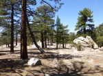
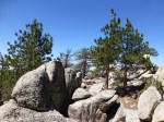
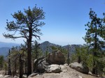
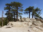
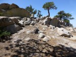
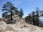
Views from Mt. Waterman (Click image to view larger size)


Pingback: New Page Additions Since July 2016 | Hiking Angeles Forest
Pingback: My First Backpacking Trip Of The Year | Hiking Angeles Forest
Pingback: Weekly Gallery Update #4: Blue Sky Backgrounds | Hiking Angeles Forest
Pingback: Weekly Gallery Update #2: Views From Peaks | Hiking Angeles Forest