Schad, Jerry Afoot & Afield: Los Angeles County 3rd Ed. Berkeley, CA: Wilderness Press, 2010
Referenced in Posts:
- Trail Conditions Along Upper Bear Canyon (Chapter 20, Trip #7). Discusses trail conditions in Upper Bear Canyon from March 2013.
- Castle Canyon (Chapter 20: Trip 11) A description of the Castle Canyon trail including photos of the trail in the snow.
- Heart of Devil’s Canyon (Chapter 24, Trip 2). Discusses the trail conditions in Devil’s Canyon below the trail camp from February 2015 with inspiration from Joseph Conrad’s book Heart of Darkness.
- A River, A Bridge, And A Bighorn Sheep (Chapter 26, Trip 11). Discusses the hike up Lower San Gabriel Canyon to the Bridge to Nowhere.
- Ski Lift Shortcutting Our Way To Baldy (Chapter 27, Trip 7). Discusses taking the Ski Lift up to Baldy Notch and hiking the Devil’s Backbone Trail to Mt. Baldy.
Photos From Hikes: (linked hike #’s lead to my step by step instructions)
Photos from hikes described in Ch. 20: Angeles Forest: Arroyo Seco & Front Range
Note: Schad also describes hiking to San Gabriel Peak from Eaton Saddle. Route Instructions for that hike are here. Below are photo galleries (that differ from above) for this option.
- Mueller Tunnel
- Eaton Saddle to Markham Saddle
- Mt. Lowe Trail which I break into three segments as follows:
- Mt. Lowe
Trip 7: Bear Canyon. I haven’t documented all segments of this hike (though I’ve traversed all of them). See my post: Trail Conditions Along Upper Bear Canyon for more information.
- Mueller Tunnel
- Eaton Saddle to Markham Saddle
- Mt. Lowe Road (Segment information with photos of junctions only)
- Tom Sloan Saddle Trail
- Upper Bear Canyon Trail to Bear Canyon Trail Camp
Trip 11: Mt. Lowe Railway. See my post: Castle Canyon for more information about the Castle Canyon Trail portion of this trip.
- Lower Sam Merrill Trail
- Lower Mt. Lowe Railway Trail
- Upper Mt. Lowe Railway Trail
- Castle Canyon Trail
Trip 12: Inspiration Point
- Mueller Tunnel
- Eaton Saddle to Markham Saddle
- Mt. Lowe Trail which I break into three segments as follows:
- East Mt. Lowe Trail
- Mt. Lowe Road (Segment information with photos of junctions only)
- Lowe Saddle
- Inspiration Point
- Mt. Lowe
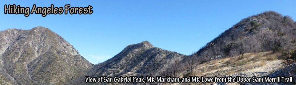
- Upper Sam Merrill Trail (A.K.A. West Mt. Lowe Trail).
- Barley Road (Schad refers to as abandoned fire road)
- South Strawberry Saddle Trail (Schad refers to a trail on the left)
- Strawberry Peak Trail (Schad refers to overgrown fire break)
- Strawberry Peak.
Photos from hikes described in Ch. 21: Angeles Forest: Mount Wilson & Front Range
Trip 5: Mt. Wilson Loop. I’ve only added segment pages that show photos of just the junctions.
Trip 12: Valley Forge & Devore Trail. I’ve only documented the Valley Forge Portion
Trip 13: Angeles Crest to Chantry Flat (I’ve only documented one segment)
Photos from hikes described in Chapter 22: Charlton-Chilao Recreation Area
Trip 2: Vetter Mountain The trail Schad describes was burned in the Station Fire of 2009. The above link provides the current route description.
- Angeles Crest Parking to JCT Silver Moccasin Trail
- JCT Silver Moccasin Trail to Vetter Mountain.
- Vetter Mountain
Trip 4: Mt. Hillyer (I haven’t yet documental all segments of this trip). However, this trip gives route instructions to Mt. Hillyer without the described loop to Santa Clara Divide Road. Also, this trip is longer but more interesting (in my opinion anyway) than going the Santa Clara Divide route.
Photos from hikes described in Ch. 24: San Gabriel Wilderness
Trip 2: Upper Devil’s Canyon. See my post: Heart of Devil’s Canyon for more information.
- Middle Devil’s Canyon. (Schad refers to as “fairly distinct path after the trail camp).
Trip 4: Mt. Waterman Trail
- Mt. Waterman Trail
- Mt. Waterman Summit Trail (Schad refers to as “a trail to Waterman’s rounded summit).
- Mt Waterman Trail JCT summit trail to JCT Twin Peaks. (Schad describes as “zigzag south down to a second junction …”)
- Mt. Waterman Trail JCT Twin Peaks to Three Points (Schad describes as, “then stay right (west)” ).
Trip 5: Waterman Mountain & Twin Peaks (I haven’t documented the entire route).
- Mt. Waterman Trail
- Mt. Waterman Summit Trail (Schad refers to as “a trail to Waterman’s rounded summit).
- Mt Waterman Trail JCT summit trail to JCT Twin Peaks. (Schad describes as “zigzag south down to a second junction …”)
- Mt. Waterman
Photos from hikes described in Ch. 25: Angeles Forest: High Country & North Slope.
Trip 1: Cooper Canyon Falls
- Burkhart Trail: Buckhorn Campground to JCT Cooper Canyon Trail
- Burkhart Trail: JCT Cooper Canyon to JCT Rattlesnake Trail
Trip 4: Mount Islip–North Approach (the version described in the note at the end of the description starting from Islip Saddle and following the PCT.
- PCT: Islip Saddle to Little Jimmy
- PCT: Little Jimmy to Windy Gap
- Islip Ridge Trail: Windy Gap to Mt. Islip
- Mt. Islip Trail: Mt. Islip to Little Jimmy
- Mt. Islip
Trip 5: Mt. Williamson
- PCT: Angeles Crest to JCT Pleasant View Ridge
- Pleasant View Ridge: PCT to Mt. Williamson (Schad refers to as “unmaintained but well beaten path.”)
Trip 6: Pleasant View Ridge (I haven’t documented the last segment of this trip)
- PCT: Angeles Crest to JCT Pleasant View Ridge
- Pleasant View Ridge: PCT to Mt. Williamson (Schad refers to as “unmaintained but well beaten path.”)
- Pleasant View Ridge from Mt. Williamson to middle Mt. Williamson (Shad refers to as “unnamed point”)
- Pleasant View Ridge from middle Mt. Williamson to west Mt. Williamson (Shad refers to as “unnamed point”)
- Pleasant View Ridge from west Mt. Williamson to Pallett Mountain (Schad refers to as “many very sharp rocky descents”)
- Pleasant View Ridge: Pallett Mountain to Buckhorn Saddle (Schad refers to as a well-worn climber’s path).
Trip 11: Burkhart Trail (I’ve documented just from Buckhorn Campground to Burkhart Saddle)
- Burkhart Trail: Buckhorn Campground to JCT Cooper Canyon Trail
- Burkhart Trail: JCT Cooper Canyon to JCT Rattlesnake Trail
- Burkhart Trail: JCT Rattlesnake Trail to Burkhart Saddle
Photos from hikes described in Ch. 26: Angeles Forest: Big Pines & Sheep Mountain Wilderness
Trip 5: Mt. Baden-Powell Traverse
- PCT: Vincent Gap to JCT Mt. Baden-Powell
- PCT: JCT Mt. Baden Powell to JCT Dawson Saddle
- Dawson Saddle Trail
- Throop Peak Trail
- Throop Peak
- Mt. Burnham
- Mt. Baden-Powell
Trip 11: East Fork to Bridge See my post A River, A Bridge, And A Bighorn Sheep for more information.
Photos from hikes described in Ch. 27: Angeles Forest: San Antonio Canyon & Old Baldy
Trip 5: Cucamonga Peak
- Lower Icehouse Canyon
- Lower Chapman Trail
- Upper Chapman Trail
- Middle Icehouse Canyon
- Upper Icehouse Canyon
- Cucamonga Peak Trail
- Cucamonga Peak
Trip 7: Old Baldy–East Approach. See my post: Ski Lift Shortcutting Our Way To Baldy
Trip 8: Old Baldy–South Approach
