
Below is a list of links to new and updated pages between April and the end of June 2017. I’ve found the changes regarding recording the hikes I do to be manageable and I anticipate being able to continue to create or update a page for each hike I do which provides a track map and a route description (at a minimum) for the foreseeable future. That said, I continue to deal with unexpected off trail distractions, but, hope to get started writing posts for the peaks in my 12 peak challenge soon.
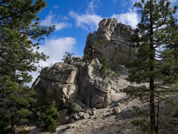
My favorite hike in Angeles National Forest this quarter was a tie with hikes #28 and #29. Those hikes were done consecutively exploring the hike’rs trails that connect Angeles Crest mile marker 54.10 to roughly the center of the West Ridge of Mt. Waterman, On the first day I followed the west ridge to Mt. Waterman. On the second day, I followed the west ridge back down to the south Mt. Waterman Trail near Three Points. This photo is of my favorite of the numerous rock outcrops along the west ridge.
Clicking on links below will open the page in a new tab so that it will be easier to follow links on those pages and still get back to this one.
Hiking Journal
- Added hikes #18 through #36 on my 2017 Hikes Page.
New Hike Pages (also updated on My Hikes by Distance Page)
- Trail Canyon to Falls and Tom Lucas CG Area
- Chantry Flat to Hermit Falls to Sturtevant Falls to Spruce Grove CG
- Crystal Lake CG to Mt. Islip Loop.
- Crystal Lake CG to Throop Peak and Mt. Hawkins
- Manzanita Trail: South Fork to Vincent Gap
- Rosenita Saddle to Mt. Hillyer Lollipop
- Eagles Roost to Mt. Williamson (all bumps)
- West Mt. Waterman Trail and Upper West Mt. Waterman Ridge to Mt. Waterman
- West Mt. Waterman Trail and Lower West Mt. Waterman Ridge Loop
- Mt. Williamson Shuttle Hike: Islip Saddle to Angeles Crest Hwy mile marker 62.50
- Baldy Bowl Trail and Devil’s Backbone Trail Loop to Mt. Baldy
- Red Box to West Fork Campground Lollipop
- Islip Saddle to Middle Mt. Hawkins and Mt. Islip
Angeles Forest 12 Peak Challenge
- Added several hikes to My 12-Peak Challenge Page. I’ve now hiked to each peak at least one time this year.
52 Hike Challenge 2017 Page.
- Added hikes #11 through #19 on my 52 Hike Challenge 2017 page. Note: I’m only including different hikes in Angeles National Forest that go to one of the 12 peaks in my 12-Peak Challenge.
New Peaks (also updated on My Peak Bagging Routes Page)
- Pinyon Peak: Garland Ranch Regional Park
Updated Peaks (also updated on My Peak Bagging Routes Page)
- Mt. Waterman: added a new route.
- Mt. Williamson: added a new route.
- Throop Peak: added a new route.
- Mt. Hillyer: added a new route.
- Mt. Hawkins: added a new route.
- Middle Mt. Hawkins: added a new route.
- Mt. Islip: added a new route.
New Trailhead Pages (also updated to My Map Page)
- Trail Canyon
- Crystal Lake Campground
- South Fork Trailhead / Campground
- Rosenita Saddle
- Eagle’s Roost Picnic Area
- Angeles Crest Mile Marker 54.10
- Angeles Crest Mile Marker 62.50
Updated Trailhead Pages
- Chantry Flat: added a new route.
- Angeles Crest mile marker 54.10: added a new route.
- Islip Saddle: added two new routes.
- Red Box: added a new route.
- Manker Flats: added a new route.
Updated Points of Interest Pages
- Inconspicuous Trail Camp: added a new route.
New Trail Photo Galleries (also updated to My Map Page)
- North Mt. Hillyer Trail
- West Mt. Waterman Trail
- Lower West Mt. Waterman Ridge
- Upper West Mt. Waterman Ridge
New Trail Segment Pages
- North Mt. Hillyer Trail
- West Mt. Waterman Trail
- Lower West Mt. Waterman Ridge
- Upper West Mt. Waterman Ridge
New Photo Galleries (outside Angeles National Forest)

Hi Kyle – you say “—Track map for Baldy Bowl Trail and Devil’s Backbone Loop to Mt. Baldy from June 2017 using Backcountry Navigator (US Forest Service-2013 map) from my phone”. I am in the market to upgrade my GPS to a phone-based one. I searched the Apple Store for “Backcountry Navigator” but couldn’t find it. Your map and route looks good and I may be interested. Can you be more specific about what you use?
LikeLike
Hi Norbert, I think Backcountry Navigator is Android only. See: https://play.google.com/store/apps/details?id=com.crittermap.backcountrynavigator.license&hl=en
LikeLiked by 1 person
Ahhh, that’s why. I use a Garmin, but I don’t like its battery life. Too many AA to carry. But everything I try on the iPhone is crappy – in my opinion.
LikeLike