Mueller Tunnel re-opened: Hike from Eaton Saddle to Mt. Lowe

On my hike last Wednesday I learned that Mueller Tunnel and the road connecting Eaton Canyon to Markham Saddle was re-opened.  Last Saturday I hiked with family and friends from Eaton Saddle to Mt. Lowe.  This short hike is filled with views of peaks and canyons from different perspectives as it winds along parts of the San Gabriel Peak and Mt. Markham on the way to the summit of Mt. Lowe that has additional views as far as Catalina Island (on a clear day).  More distant peaks are also clearly in view. See more information and photos here

View of Mueller Tunnel from Mt. Markham

Hike to Echo Mountain, Mt. Lowe, San Gabriel Peak, Mt. Disappointment, and Mt. Markham

On 2-22-12 I did a 20.6 mile hike with 6563 feet of gain.

I started at the Cobb Estate Trailhead (Corner of Lake Ave. and Loma Alta Drive) and hiked up the Lower Sam Merril Trail to Echo Mountain, took the Castle Canyon Trail to Inspiration Point, went up the Middle West Sam Merril Trail to Mt. Lowe, down to Markham Saddle, then up to San Gabriel Peak; down to the San Gabriel Peak Trailhead (near the corner of Mt. Wilson Road and Mt. Disappointment Road), back up to Mt. Disappointment, down to Markham Saddle, Up to Mt. Markham, and back down the Upper East Sam Merril Trail, the Middle Sam Merril Trail and the Lower Sam Merril Trail to the Cobb Estate Trailhead.

Since there were 19 different trail segments, It will take me a while to post the hike here.  I’ve hiked most of the portions of this trail several times starting back in January 2011.  So, I will start posting those earlier shorter hikes and build up to completing this one.

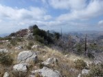
I met a group of hikers from the Sierra Club who told me how to hike up to Mt. Markham.  I was lucky to have met them as I really enjoyed that portion of my hike.  Below is a photo of the San Gabriel Peak from Mt. Markham.

Silver Moccasin Trail from Angeles Crest Highway to Little Pines Loop

On 2-18-12, I hiked a portion of the Silver Moccasin Trail. This hike is mostly through recovering burn areas.  Many burned trees stand relatively alone along hilly parts of the landscape with expansive views.  I often felt like I was trekking through a memorial simultaneously capturing the respect and admiration for what was and the sadness for what is now lost.  With some small patches that appear to have survived with little harm and the forest regenerating itself throughout, this hike offers a nice variety of landscapes to walk through.  The trail is maintained and easy to follow throughout.  At Charlton Flats however, portions of the trail are closed to all users and continuation is achieved by walking about a half mile along the paved road until it meets up again with the trail at the north end of the picnic areas. See more information and photos here.