
I’ve hiked from Dawson Saddle over a dozen times, but I only made it up to Mt. Lewis for the first time last Saturday. I confess I was told to go a few years ago on a day I went snowshoeing up the Dawson Saddle Trail toward the PCT. As I was getting my snowshoes on another hiker arrived at the trailhead having just finishing snowshoeing to Throop Peak. He told me that he had a great trip to the peak and was now going to take his snowshoes off and hike to Mt. Lewis (a short distance across Angeles Crest Highway from where we stood). He said that he does this often and really enjoys the juxtaposition of snowshoeing and hiking on the same trip. As we parted ways, he assured me that a quick hike up to Mt. Lewis was worthwhile. Although I also had a great day snowshoeing (only my second time), I wasn’t up to doing the additional hike afterword.
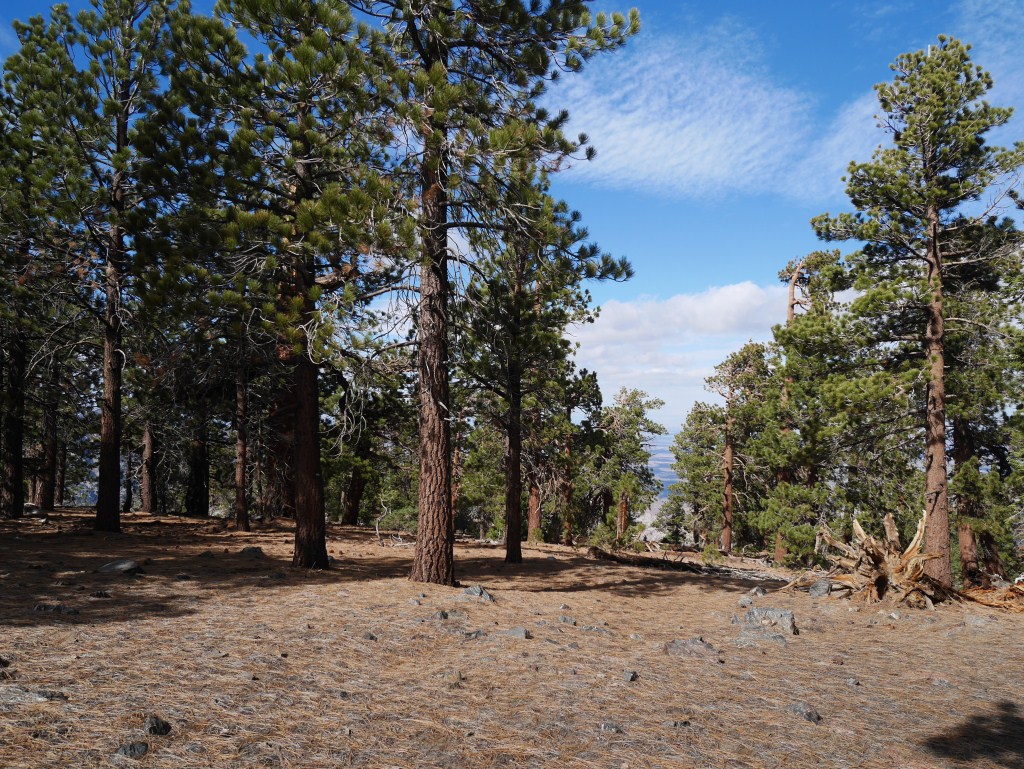
View toward the Antelope Valley from the densely forested Mt. Lewis
For me, a lot goes into determining where to hike that has little to do with the beauty of a particular place in the forest. Although it always looked to me that it might be interesting to summit, the trail is only a mile round trip and is over an hours drive to reach from the 210 freeway. That’s too much driving for such a short hike to be worth doing for me on its own. Frankly, the terrain behind it is so great that I’ve only allowed time and energy to hike those spectacular areas which left Mt. Lewis unexplored by me. Now that I’ve been there, I believe this peak would be almost as popular to climb as the others close by if there was a much longer trail to get to it. I combined it with Throop Peak creating a worthwhile short day on the mountain travelling 5.2 miles with 1,728′ of gain and loss. I think the key to hiking Mt. Lewis is to hike it first and then cross Angeles Crest Highway to combine it with something much longer. Over the past few years, I’ve always ended up just going home after hiking whatever I hiked first–reaching my car after an already satisfying and tiring hike always proved to inspire procrastination.

View from the steep Mt. Lewis use trail. Note the trail goes from bottom to top on the left side of this photo.
It is important to point out that this trail isn’t for everyone. It is an un-maintained use trail that has very steep parts to it, is thin in many places, and often has a steep drop to one side. The steepest part is over the first quarter mile.

View toward Throop Peak from the heavily wooded trail.
The trail is heavily wooded which noticeably slowed down the gusting wind as compared to what it was like at Dawson Saddle and Throop Peak on Saturday.

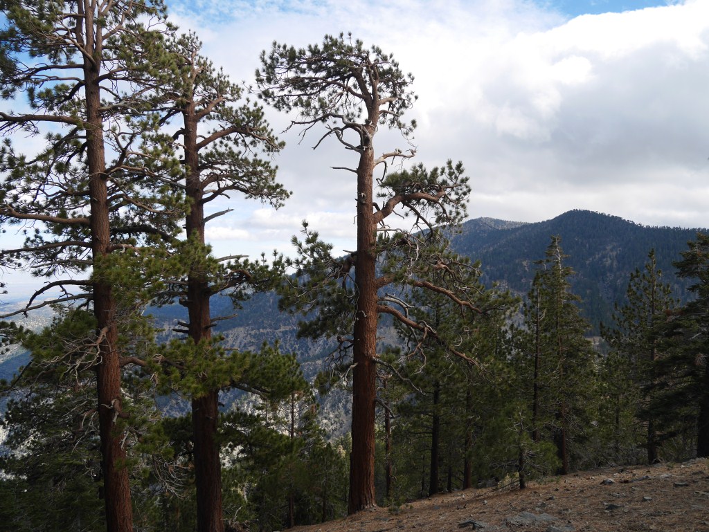
Mt. Burnham (Left) and Throop Peak provide a nice background to the long view down the trail.
The views from the trail are often dramatic. In many ways this is due to the trees partially blocking the long view creating many interesting panoramas as major landmarks come in and out of view. The interplay of foreground and background is often engrossing. In fact, the trail and peak are so wooded that getting a completely unobstructed view out to a desired landmark requires a significantly higher degree of focused effort than is typically the case. I’m not saying it’s hard to do. It is just a different and more nuanced visual experience than being on terrain with completely unobstructed views. In a way, it’s similar to being inside looking out.
View toward Mt. Baden-Powell (left) and Mt. Burnham from the trail.
This quasi inside feeling makes the landmarks feel a little more special when they do come into clear view. That I love seeing the forest and its landmarks from different perspectives made this quality very appealing to me. The series of glimpses out combined with the more intimate interior spatial changes of the terrain along the trail made the short half mile to the peak interestingly varied. My sense of anticipation regarding what I would see after traversing another hundred feet or so was constant.

Typically enclosing space on Mt. Lewis
I was pleasantly surprised when I reached the peak and found it spatially enclosed by trees. I concede that on one level I was disappointed that the unobstructed 360 degree view out I had expected didn’t exist. However, there are views in all directions, just not from the same spot and the process of seeking them out is interesting and fun. Also, the peak itself is on the larger and more flat end of the spectrum compared to other peaks nearby. So, some walking around to find these good angles is required and the possible great views are unlikely to all be seen on a single trip.

View toward Twin Peaks from one of the southern breaks in the trees on Mt. Lewis
Unlike the super windy conditions at Dawson Saddle, there was only a slight breeze on Mt. Lewis and it was significantly warmer due to the protection provided by the trees. This level of protection combined with numerous areas of flat enough ground to pitch a tent got me thinking about camping here sometime in the future. I noticed I’m not the only person whose thought of this. Unfortunately, I saw remains of a camp fire which is not allowed in this area for obvious reasons. I sincerely hope that anyone inspired to camp on Mt. Lewis due to this post will obey the fire restrictions in place for this area which only allow the use of a portable stove etc.

The protection from wind combined with fairly flat terrain on the peak makes Mt. Lewis an interesting option for camping.
I’ve been thinking about hiking to Ross Mountain sometime next year (a destination following the ridge down the south side of Mt. Baden-Powell about 2,000′ lower in elevation). This would be a long day hike which would benefit from my being able to start early from Dawson Saddle. The option to spend the night on Mt. Lewis and then swap gear at my car before embarking on such a trek is very appealing to me and is now the most likely way I’ll attempt to reach Ross Mountain. I also look forward to returning to Mt. Lewis to spend the time to look around more which would be a perfect thing to do on a late afternoon before spending the night.

One of my favorite places to spend the night
LikeLike
Lovely photos of an area I know very well from hiking my beloved San Gabriels for 55+ years till moving to Washington State…
LikeLike
Another fine job, Kyle. Keep it up.
jim
LikeLiked by 1 person
Wonderful photos — I enjoyed your journey!
LikeLiked by 1 person